|
The
course directions for 2017
Start is in the Coburn Park - off of 10th Street Alley in Downtown Coburn,
PA
Proceed West on Georges Valley Rd. SR 2012
Left on Siegerville Millheim Pike
Right on Mt. Church Rd.
Left on Decker Valley Rd. to 322 Junction
Cross 322 onto Crowfield Rd
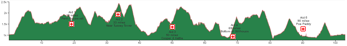
Continue on Crowfield Rd to Penn Roosevelt State Park (Aid Station
#1)
Right on Thickhead Mountain Rd.
Left on Detweiler Run Rd.
Right on Bear Meadows Rd.
Left on Longberger Path
Left on Spruce Gap Trail
Right on Three Bridges Trail
Left on Laurel Run Rd.
Left on Litte Flat Tower Road (NEW)
Climb to (Aid Station #2)
(NEW)
Right on New Laurel Trail
(NEW)
Left on Laurel Rd
(NEW)
Left on Bear Gap Rd
(NEW)
Left on Croyle Run Trail
(NEW)
Left on Beedleheimer
Left on Stone Creek Rd
Right on Coopers Gap Road
(NEW)
Left on Dutch Alvin Trail
(NEW)
Left on Coopers Gap Road
(NEW)
(Aid Station #3)
(NEW)
Right up Kettle Road
(NEW)
HARD
Left on Sassafras Trail
(NEW)
Right on Sasspig Trail
(NEW)
Left on Pigpile Trail
(NEW)
Left on Barrville Road
(NEW)
HARD Left on Flat Road
(NEW)
Right on Sassafras Trail
(NEW)
Continue on Lewistown Contingent Trail
Left on Coopers Gap Rd.
Right on Conklin Rd.
Right on Beautiful Trail
Left on No Name Trail
Right on Lingle Valley Rd.
Left on Old 322 (Aid
Station #4)
Right on Stillhouse Hollow Rd.
Right on Sand Mountain Rd.
Right into Sand Mountain Parking lot
Continue on Sand Mountain Trail out of back of Parking Lot
Right on Lingle Valley Trail
Follow Lingle Valley Trail around to the left and proceed on Faust Valley
Trail
Right back onto Sand Mountain Road
Right on Siglerville Millheim Rd.
Continue up Siglerville Millheim Rd
Straight over the top (NO Panther Run -new 2017)
(NEW)
Left on HAVICE VALLEY ROAD
(NEW)
Havice Mountain Road becomes Paddy Mt. Road
(NEW)
Right into Poe Paddy State Park (Aid Station #5)
Right onto Foot Bridge over Penn's Creek Through Tunnel onto Railroad
Grade
Follow Railroad Grade to SR 3002
Continue same direction on SR3002
Left on Cherry Run Rd.
Left on Old Mingle Rd.
Right at end of Old Mingle Rd. onto Fisherman's path
Follow to Railroad Grade and follow into Ingleby In Ingleby (by the
hanging rock)
continue around cable on Railroad Grade
Cross Foot Bridge over Penn's Creek
Go straight through Tunnel
Bear Left exiting tunnel
Continue towards Coburn
Right turn towards Coburn over the bridge
Right on 10th Street Alley into Coburn Park
|